At On The Mark Surveys, our FAA-certified drone pilots deliver fast, accurate, and safe data alongside professional-grade photography and videography. From 3D modeling to cinematic property tours, we provide tailored solutions for architects, contractors, real estate professionals, government entities, private corporations, and developers nationwide.
Why Choose OTM Drone Services?
With over a decade of experience, we combine cutting-edge drone technology with personalized service to elevate your projects. Here’s why clients trust us:
Precision
Coming Soon
Achieve survey-grade precision with RTK-enabled drones, GCPs, LiDAR, and photogrammetry—delivering 2–3 cm accuracy for site plans, volumetrics, 3D models, and more.
Speed
Survey large sites in hours, not days, saving you time and resources.
Visual Impact
Capture stunning aerial photos and videos for marketing and presentations.
Safety
Eliminate risky manual inspections with drone-based solutions.
Versatility
Combine survey data and visuals in one flight for maximum efficiency.
Nationwide Reach
Serving with local expertise in Phoenix, Los Angeles, and beyond.
Our Drone Services
Our advanced drone technology delivers actionable data and compelling visuals for your architectural needs. Explore our comprehensive offerings below.


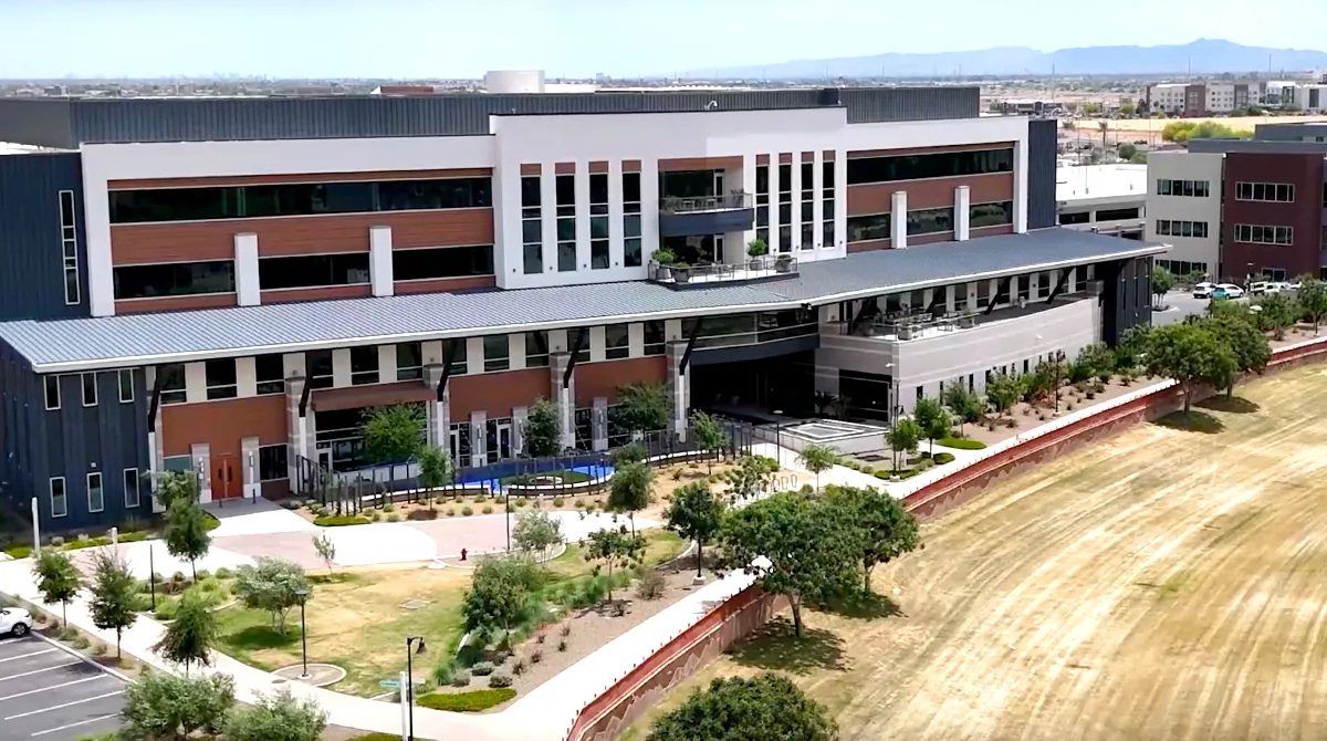
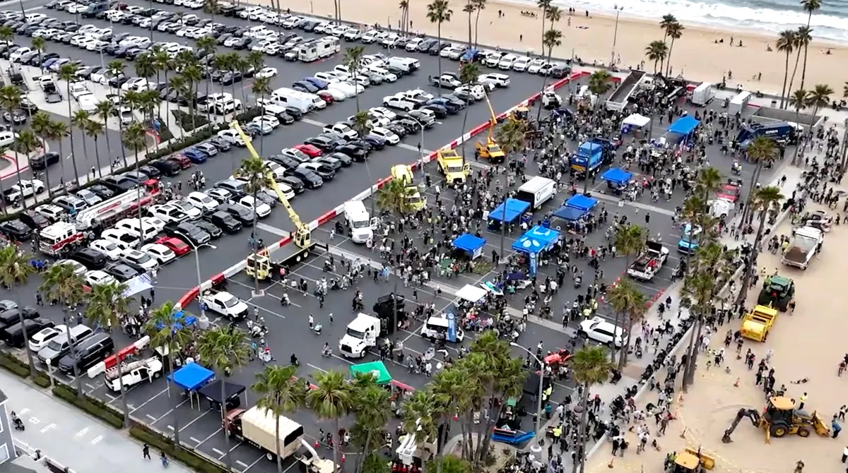
Aerial Photography
High-resolution aerial photography with OTM delivers visually striking images from unique vantage points—perfect for enhancing property portfolios, real estate marketing, construction documentation, and heritage preservation. Our FAA-certified pilots and photogrammetry-trained teams use advanced drone platforms equipped with calibrated cameras to capture crisp, vibrant imagery. Each shoot is carefully planned using flight path optimization and sun-angle analysis to ensure optimal lighting and shadow mitigation.
Delivered as professionally edited JPEGs or PNGs, our aerial photographs enable clients to:
Whether you’re refreshing a real estate listing, preparing a site report, or documenting as-built conditions, our aerial photography service merges marketing finesse with technical precision.
Aerial Videography & 360° Virtual Tours
Transform spaces into cinematic experiences with our aerial videography services and immersive 360° virtual tours. Using drones that support stabilized 4K capture and multi-axis gimbals, we deliver smooth, high-definition video optimized for storytelling and stakeholder engagement. Ideal for real estate showcases, developer walkthroughs, project documentation, or cinematic brand content, our service includes:
Flight plans are developed with safety and FAA compliance top-of-mind. Our pilots are trained to fly safe, efficient mission profiles that align with airspace restrictions, site logistics, and on‑site personnel. The result: an engaging, high-quality visual narrative that works across marketing, investor outreach, and digital content channels.


Orthomosaic Mapping & 3D Modeling
Coming Soon
OTM combines orthomosaic mapping and 3D modeling into a powerful survey-grade solution. Using high-overlap imagery and precise control measures, we create georeferenced orthomosaic maps and photogrammetric point clouds ideal for architectural site planning, BIM integration, and volumetric analysis. Key benefits include:
Our workflow encompasses pre‑flight site planning, in-field data capture, post‑processing with Pix4D/Metashape, and QA/QC review. The result: detailed, actionable data that empowers architects and engineers with spatial insight—all delivered through secure digital portals.


Topographic Surveys & Thermal Imaging
Coming Soon
For terrain and structural insights, OTM offers topographic surveys and drone-mounted thermal imaging:
Drones vs. Traditional Surveys: Why Choose OTM?
|
Speed |
Hours to survey large sites |
Days or weeks for manual surveys |
|
Accuracy |
2-3 cm with RTK drones |
Varies, often less precise |
|
Cost |
Up to 30% savings |
Higher due to labor and equipment |
|
Safety |
No risky fieldwork |
Requires scaffolding or climbing |
|
Visual Output |
Stunning photos/videos included |
Separate photography services needed |
|
Environmental Impact |
Low carbon emissions |
Heavy equipment increases footprint |
How Our Drone Services Work
We create precise deliverables and polished visuals using advanced software
Consultation
We discuss your goals, whether it’s survey data, photography, videography, or a combination.
Flight Planning
Our fully insured, FAA-certified pilots plan safe, efficient flights using the latest drone technology to deliver accurate and reliable aerial data.
Data Capture
We collect high-resolution survey data, photos, and 4K video in a single flight.
Processing
We create precise deliverables and polished visuals using advanced software.
Delivery
Receive survey files, edited photos, and videos via secure portals within days.
Frequently Asked Questions
What types of drone services do you offer?
We provide aerial photography and video tailored to architectural and real estate needs. Coming soon: Orthomosaic mapping, 3D modeling, topographic, and thermal imaging services.
Can you capture survey data and visuals in one flight?
Yes! Our drones collect precise survey data and high-quality photos/videos simultaneously, saving you time and costs.
What is the turnaround time for photos or videos?
Edited photos and videos are typically delivered within 48-72 hours, depending on project scope.
Are your pilots FAA-certified?
Yes, all our pilots are FAA Part 107-certified, fully insured, and committed to strict safety and airspace regulations. With decades of combined experience in architectural surveys, graphic design, video production, and marketing, our team delivers tailored solutions that meet your project’s unique needs with precision and professionalism.
What deliverables can I expect?
Survey deliverables include point clouds and CAD files. Photography and videography deliverables include edited JPEG/PNG images, MP4/MOV videos, or interactive 360° tours. Orthomosaics, DTMs and more mapping options coming soon.
Serving Nationwide with Local Expertise
Based in Arizona, we proudly serve clients across Phoenix, Scottsdale, Los Angeles, San Diego, Hawaii and nationwide. Whether you’re an architect, contractor, real estate professional, or marketing professional our drone services deliver results that meet your needs.
At On The Mark Surveys, our FAA-certified drone pilots deliver fast, accurate, and safe data alongside professional-grade photography and videography. From 3D modeling to cinematic property tours, we provide tailored solutions for architects, contractors, real estate professionals, government entities, private corporations, and developers nationwide.

3D Modeling
Coming Soon
Generate detailed point clouds and BIM-compatible 3D models for as-built documentation and design integration.
Topographic Surveys & Thermal Imaging
Coming Soon
For terrain and structural insights, OTM offers topographic surveys and drone-mounted thermal imaging:
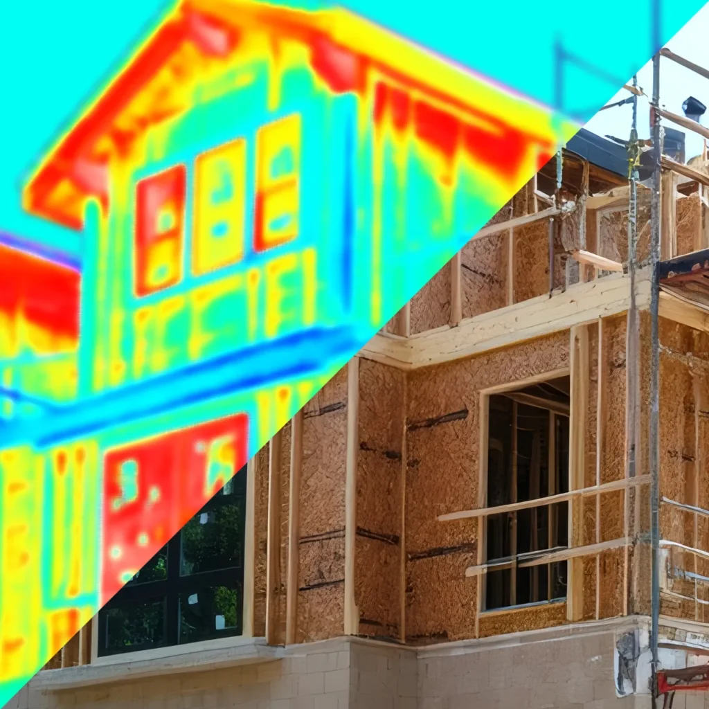
Thermal Imaging
Coming Soon
Identify structural issues like heat leaks, water intrusion, or electrical faults with drone-mounted thermal cameras.